|
St Francis |
|

New Zealand Travel Notes
Notes from our Trip around NZ March - April, 2015
|
Books and Reference Material |
|
| Lonely Planet Guide to New Zealand | Another good pub from Lonely Planet. We didn't actually use our LP much once we got to NZ, because the NZ iSites provide so much information, it was simpler to use that. We did use the Frenzy guides a LOT. |
| NZ Frenzy - South Island | By Scott Cook. A great guide to off-the-beaten path hikes all over the South Island. Highly recommended. |
| NZ Frenzy - North Island | By Scott Cook. A great guide to off-the-beaten path hikes all over the North Island. Highly recommended. |
|
Useful Apps for Android/iPhone |
|
|
Google Maps |
We used the Google Maps whenever we had cell coverage. It never steered us wrong, EXCEPT in one case on Stewart Island, where it routed us on a very bad rocky dirt road instead of on the much better (but slightly longer) gravel road. |
|
Maps with Me (maps.me) |
Though Google Maps works well for driving directions in NZ, you
don't always have the cell coverage you need to use Google Maps.
Plus Maps with Me also has most hiking routes, huts, and sights
marked, and has more detail in most places than Google Maps.
There is a free version of Maps.me, but to get the routing, you have
to get the paid version--costs about $15. Then you can
download the entire set of maps for New Zealand, so you always have
a map even without any internet. This saved our butts several
times The NZ maps were very good, and the routing works (for
cars)--though no voice guidance. |
|
Booking.com |
Hands down my favorite hotel booking app. Quick and easy to use, and covers NZ well. Has many backpacker and holiday parks in every town. |
|
XE |
A simple exchange rate app, that keeps updated exchange rates for up to 8 stored countries. Very helpful when traveling. |
|
NZ Great Walks |
Has downloadable sections on all of NZ's "Great Walks", plus a very helpful bird reference. |
|
New Zealand Maps |
I can't remember if I paid for this one. But this is useful if you want to go hiking or biking. You can download topo maps for all of NZ or Open Street Maps or Open Bike Maps. I think I paid for a "pro" version that would cache the maps, but at least with the Topo maps, the cacheing isn't easy (similar to Google Earth, you have to zoom over your area of interest at multiple levels to cache everything). |
|
Money |
|
|
Almost everyone everywhere takes credit cards--they are used to international travelers and we never had a problem with our credit card. ATMs are all over. When we were in NZ, the US exchange rate was about $.75 USD to $1 NZD. |
|
|
|
|
|
We rented a car. We used Apex, a NZ company that rents slightly older cars (imported used from Japan)--about 6 years old. It is possible to get around NZ pretty well without renting a car or camper. There are route buses that go to all the popular towns and places. There is a backpacker hop-on/hop-off service that circles the South Island, with buses going every day. Our car cost approx $30 USD/day, and got 38 mpg. It was a Nissan Versa and was sized to be big enough to take 4 (friendly) people and a moderate amount of luggage. A smaller car is available at a cheaper rate. We did not pay for extra insurance coverage other than that required by the car rental company, in the (mistaken) belief that both our credit card and our own insurance company in the U.S. provided some coverage. After we dented the rear bumper, we found neither covered us (credit card covers only for rentals less than 2 weeks, auto insurance provides no overseas coverage). Our choice of car vs camper van was based on the fact that we really preferred (and could afford) staying in budget accommodations vs sleeping in a cramped camper. The car gets much better mileage, and camping spaces in most places cost nearly as much as a backpacker room or cabin. (except in spots where "freedom camping" is allowed). |
|
|
|
|
|
We booked our stays primarily on 2 sites - Booking.com - YHA New Zealand In the end, we preferred the YHA sites when available and when we could book a private room. The YHA's usually have a big kitchen and more intrepid travelers (who are always great to learn from). The sites we booked on Booking.com were mostly cabins at campgrounds--sometimes with ensuite bathrooms and sometimes with cooking facilities. |
|
|
|
|
|
NZ Telecom (aka Spark) has MUCH MUCH better coverage in South Island than the Vodafone sim that we got originally at the airport in Christchurch--at least for our unlocked-ATT phones. Vodafone has OK coverage in the big cities, just not much in more rural areas. (in 2015) The problem was that Vodafone was the only game in town when arriving at the airport in Christchurch after hours. We finally had time in our busy touring schedule to visit the Spark store in Queenstown.Pretty much every place we stayed in 2015 had wifi. Some were free and some were paid. I think that getting a YHA membership entitled you to free wifi at YHA sites. Also, if you are using a NZ Telecom/Spark sim, there are Spark hotspots in most cities that you can use for free. |
|
|
About the Trip |
|
|
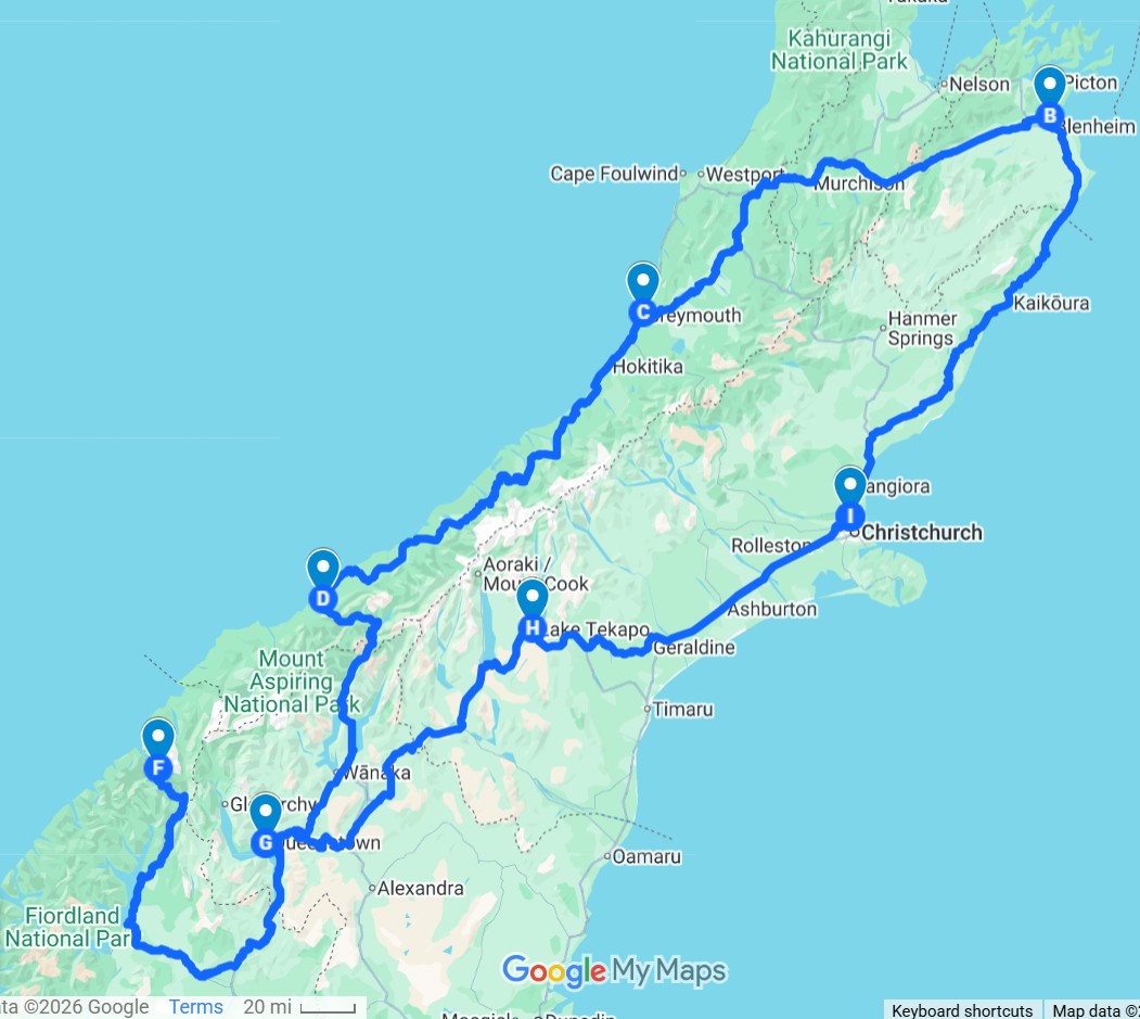
The first 2 weeks of our 2 month visit, we had other cruising friends join us, and we stuck to the South Island. Because of trying to fit the highlights of the South Island into only 12 days, we had a pretty aggressive, planned schedule. See map below for this first circuit of the South Island... Christchurch, Blenheim, Greymouth, Haast, Queenstown, Milford Sound, Lake Tekapo, and back to Queenstown.
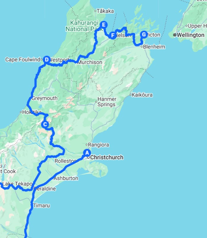
See this day-by-day with details as pdf After our friends left, we plotted out the rest of the trip, to "do" the South Island more thoroughly and then take the ferry across to North Island and "do" the North Island. With our "Frenzy" books, and Tourist Information Centers located in almost every town, we had plenty of information on hand for each next stop. Below, the northern half of our second trip around the South Island. We went all the way south to Stewart Island and then all the way north to the north end of the South Island before crossing over to Wellington on the car ferry.
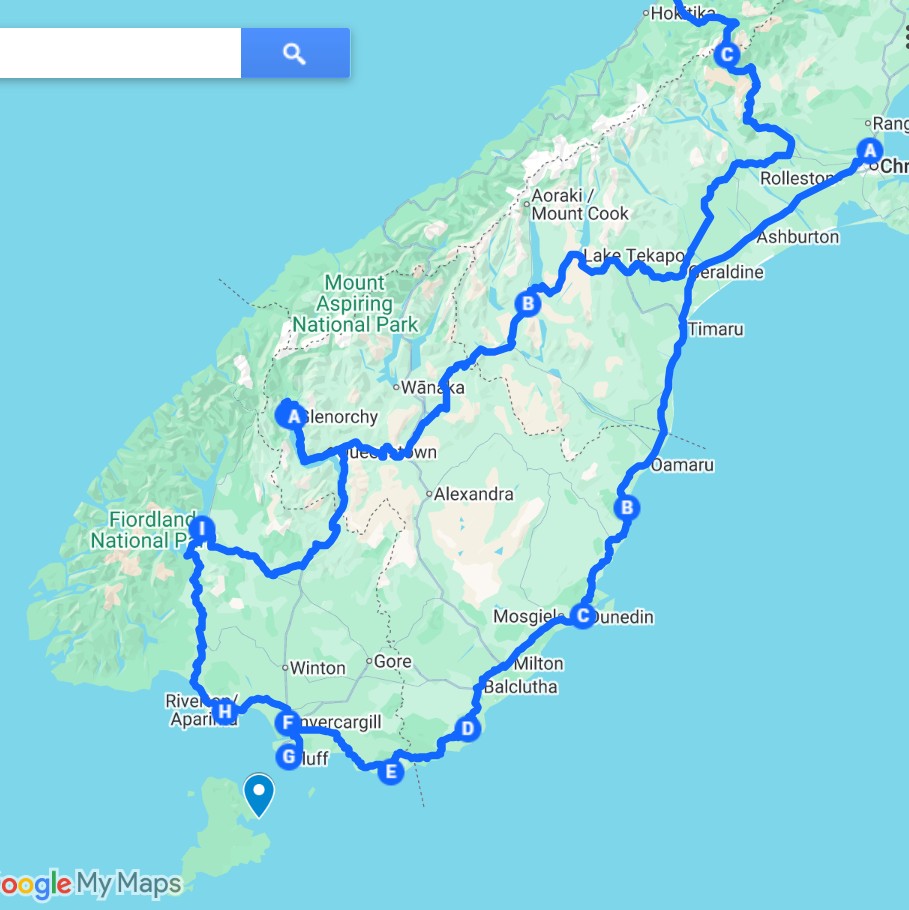
Below, the southern half of our trip around the South Island.
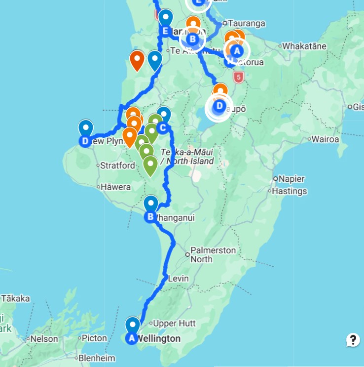
Our knees and planning were not good enough for us to partake in any of the full "Great Walks" (7-10 day hikes thru the countryside), but we DID manage the one "great walk" that was done by canoe, on the Whanganui River in the middle of the North Island. We didn't pick the greatest weather window for that trip, but we had fun anyway. We organized the trip with Taumarunui Canoe Hire, who picked us up at the Bridge to Nowhere at the bottom of the river trip. Below, the southern half of the North Island.
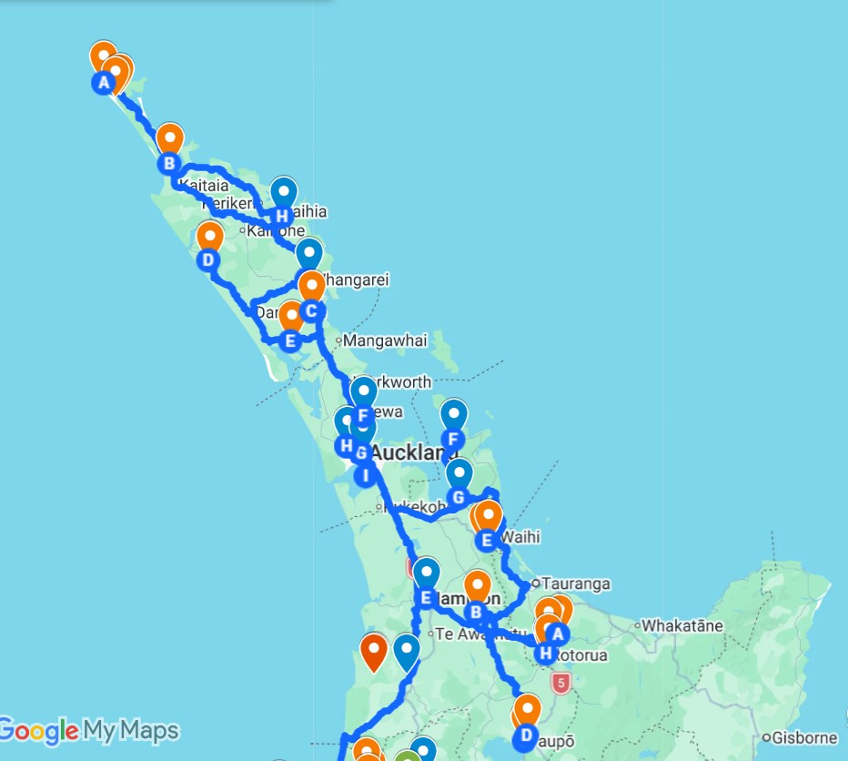
We had a number of cruising friends--both NZ residents and cruisers in marinas--that we wanted to see, so we stayed free a few nights with them, in Auckland, Opua, and Whangerei. Below, the northern half of the North Island
The complete day-by-day, with costs and details, I kept as a spreadsheet. We HAD a copy of the index pages from the New Zealand Frenzy books that we had annotated as we went along, but gave our books away and didn't save a copy of our notations. |
|