|
St Francis |
|

|
CSY 44 |
|

Free Downloadable Satellite Charts (No Gimmicks!)
Last Updated:
03/10/2025
Here are the Satellite Charts I have made/collected for the areas we have visited in the Western Pacific, plus a few other chart sets that other people have done. Be sure to read all the cautions and 'how to's' down below. (Thanks to all those cruisers who have shared their Satellite charts with me that have been included in these sets). Note, charts made before 2020 are KAP files, those 2020 and newer are mbtiles.
For WHY you want/need Satellite charts:
SSCA Presentation on Navigation Alternatives (free PDF)
For help on setting up OpenCPN to use these charts
Getting the Most out of OpenCPN
(free PDF).
| List of other chart sources | How to Install These Charts |
| Working with OpenCPN and Navionics | |
| Red Sea | Mediterranean |
| Malaysia / Thailand | |
| Philippines | Indonesia |
| Micronesia | Marshall Islands |
| PNG (Papua New Guinea) | Solomon Islands |
| Fiji | Between Fiji & Marshalls |
| Tonga | Cook Islands |
| French Polynesia | San Blas Islands, Panama |
These are ZIP files. To save to your local hard drive, right-click on each file and select "Save As", and save to your Charts directory, then unzip them. Instructions on how to "install" the charts for the most popular charting programs are below. Instructions on using others' waypoints and tracks in your OpenCPN are included in the "Getting the Most Out of OpenCPN" presentation linked above. |
|
| Name | Size | Comments / Last Uploaded |
| Red Sea (mbtiles) | ||
| Planning Charts | 2.8 MB | mbtiles May 2020 |
| Socotra to Djibouti | 15 MB | mbtiles May 2020 |
| Djibouti to 28N | 206 MB | mbtiles May 2020 |
| 28N to Med and Gulf of Aqabi | 38 MB | mbtiles May 2020 |
| Additional Red Sea Detailed Charts | 210 MB | mbtiles May 2023 |
| Yemen S Coast | 86 MB | mbtiles Apr 2023 z15 of Yemen's South Coast |
| Yemen W Coast | 46 MB | mbtiles Apr 2023 z15 of Yemen's West Coast |
| Yemen Islands | 3.5 MB | mbtiles Apr 2023 z15 of Hanish Islands |
| Saudi Arabia Overview | 1 MB | mbtiles Apr 2023 z10 of Saudi Coast |
| Saudi Arabi Jeddah | 11 MB | mbtiles Apr 2023 z17 of Jeddah |
| Saudi Arabia Coast | 220 MB | mbtiles Apr 2023 z15 of Saudi Coast |
| Saudi Arabia Islands | 1.3 MB | mbtiles Apr 2023 Some islands in N Kaharra Reef |
| Red Sea Navionics | 46 MB | mbtiles May 2020 |
|
Red Sea
Tracks and Waypoints Waypoints only (just gpx) |
879 KB (zip) 198 KB |
Some collected tracks and waypoints for the Red Sea
passage. Updated May 11, 2023 with more waypoints, and places in Egypt that it is prohibited to stop (Port Berenice, Ras Banas, and Marsa Thelamat) |
| Ganesh Tracks 2024 | 326KB (zip) 2.9MB (gpx) |
SV Ganesh is a 50 ft monohull with a 2m draft (note, this file is now included in the Red Sea Tracks and Waypoints file just above) |
|
Note: You must be using OpenCPN v5.0 or above to use mbtiles
format charts AND have OpenGL enabled. mbtiles format allows
for better satellite chart details than KAP charts. GPX files should generally be unzipped and imported as "Layers" (one at a time using the Layers tab of the Route and Mark Manager), or in bulk by placing in C:\ProgramData\opencpn\layers folder. |
||
| These are very early in my chart-making. Coverage in random places. Not very complete. More coming soon! | ||
| Med Satellite | 600 MB | mbtiles 2023 Mostly harbor charts |
| Med Navionics | 550 MB | mbtiles 2023 Navionics, Cyprus and most of Turkey for now (more coming soon) |
| Med Tracks and Waypoints | 412 KB | GPX (zipped) |
| Amazing Grace's Charts | New mbtiles of the Med, 2024. | |
| Malaysia and Thailand are difficult to get good satellite charts, so I also made some up-to-date CMap and/or Navionics charts | ||
| Malaysia | 1.2 GB | mbtiles 2022-2024, Satellite, Navionics, CMap |
| Thailand W Coast | 760 MB | mbtiles 2022-2024, Satellite, Navionics, CMap |
| Malay and Thai Track and Waypoints | 3.5 MB | GPX (zipped) Updated Nov 2024 with Soggy Paws 2023/2024 Tracks |
| Organized from NW to SE from Indo to Bouganville, and back | ||
| NW Coast | 12 MB | KAP 2019 |
| Ninigos Islands | 13 MB | KAP 2019 |
| Hermit Islands | 10 MB | KAP 2019 |
| Manus Island | 10 MB | KAP 2019 |
| New Hanover | 14 MB | KAP 2019 |
| New Ireland | 26 MB | KAP 2019 |
| New Britain | 67 MB | KAP 2019 |
| Duke of York | 2 MB | KAP 2019 |
| Buka | 8 MB | KAP 2019 |
| Bouganville | 18 MB | KAP 2019 |
| PNG Other | 14 MB | KAP 2014-2019 |
| Our PNG gpx Trackfiles | 1 MB | Covers Philippines to Indonesia down to Honiara in
the Solomons and back. Warning: 1.1m draft! |
| PNG Waypoints | All of our anchorages and dive spots were sent to Terry! |
|
| Organized from N to S as far S as Honiara | ||
| Shortlands | 26 MB | KAP 2019 |
| Choiseul | 2 MB | KAP 2019 |
| Vella Lavella | 22 MB | KAP 2019 |
| Gizo | 6 MB | KAP 2019 |
| Kolombangara | 12 MB | KAP 2019 |
| Diamond Narrows | 5 MB | KAP 2019 |
| Vonavona | 11 MB | KAP 2019 |
| Munda | 3 MB | KAP 2019 |
| New Georgia | 40 MB | KAP 2019 |
| Rendova | 11 MB | KAP 2019 |
| Tetepare | 5 MB | KAP 2019 |
| Russell | 5 MB | KAP 2019 |
| Guadalcanal | 17 MB | KAP 2019 |
| Florida Group | 17 MB | KAP 2019 |
| Rennell | 3 MB | KAP 2019 |
| Indispensible Reef | 2 MB | KAP 2019 |
| Ndendo | 2 MB | KAP 2019 |
| Utupua | 3 MB | KAP 2019 |
| Vanikolo | 5 MB | KAP 2019 |
| Reef Islands | 1 MB | KAP 2019 |
| Miscellaneous | 2 MB | KAP 2019 |
| Our Solomons gpx Trackfiles | 1 MB | Covers Philippines to Indonesia down to Honiara in
the Solomons and back. Warning: 1.1m draft! |
| Solomons Waypoints | All of our anchorages and dive spots were sent to Terry! |
|
| A limited set of our charts for the SE Philippines is here: | ||
| Gulf of Davao | 11 MB | KAP August 2018 |
| Mindando East Coast | 25 MB | KAP August 2018 |
| Surigao Straits | 25 MB | KAP August 2018 |
| Philippines Track Files (many) | 2.3 MB | GPX files of ours and other people's tracks through the Philippines |
| Philippines Anchorages, etc | All of our anchorages and dive spots were sent to Terry! | |
| Some of our charts for Indonesia are here: | ||
| Sumatra Tracks and Waypoints | 854 KB | Zipped gpx files for import into OpenCPN. See Readme for advice. Anchorage List as PDF File |
| West Sumatra Satellite Charts | 840 MB | mbtiles Mar/Apr 2024 (A Few More June 2024) |
| West Sumatra CMap Charts | 1.1 GB | mbtiles Mar/Apr 2024 (A Few More June 2024) |
| Java Sat Charts | 230 MB | Mostly western Java, 1000 Islands, and the Sunda Strait May / June 2024 |
| Bali Sat Charts | 145 MB | N and E coast of Bali |
| Belitung Sat Charts | 382 MB | All of Belitung. mbtiles 2022 and 2024 |
| Islands Between Singapore and Borneo | 316 MB | mbtiles from 2022 and 2024 (includes additional Riau Group charts and the Anambas Islands) |
| Riau Islands | 77 MB | mbtiles from 2022 (A Few More July 2024) |
| Flores and Komodo | 314 MB | mbtiles 2022 |
| West Papua North | 32 MB | KAP 2019 |
| West Papua South | 25 MB | KAP May 2017 |
| Raja Ampat | 205 MB | KAP and mbtiles 2016-2022 |
| Sorong to Triton Bay | 630 MB | mbtiles 2022 |
| Sarangani Islands | 2 MB | Islands between Philippines and Sulawesi KAP August 2018 |
| Indo Tracks and Waypoints | 7 MB | zipped gpx files (many tracks from various boats, including ours, updated Aug 2024 to include N Sumatra to Anambas Islands) |
|
For additional charts and tons of waypoints for all of SE Asia, see Valhalla's Site (aka Terry's Topics) |
||
| Kosrae | 3 MB | Feb 15, 2014 |
| Between Kosrae and Pohnpei | 1 MB | Feb 15, 2014 |
| Pohnpei | 11 MB | Feb 15, 2014 |
| Between Pohnpei and Chuuk | 8 MB | Feb 15, 2014 |
| Chuuk | 4 MB | Feb 15, 2014 |
| Between Chuuk and Yap | 20 MB | Feb 15, 2014 |
| Yap | 4 MB | Feb 15, 2014 |
| Between Yap and Palau | 1 MB | Feb 15, 2014 |
| Palau | 7 MB | Feb 15, 2014 |
| Southern Approaches to Micronesia | 5 MB | Feb 15, 2014 |
| More Micronesia | 7 MB | Set produced in 2012, uploaded Mar 2015 Received from the Mexico gang |
| Ailinginae | .5 MB | July 7, 2013 |
| Ailinglaplap | 4 MB | September 16, 2013 |
| Arno | 1.5 MB | April 13, 2013 |
| Jaluit | 9.2 MB | September 15, 2013 |
| Kwajalein | 9.5 MB | October 22, 2013 |
| Majuro | 9.5 MB | September 17, 2013 |
| Mili | 8.5 MB | August 16, 2013 |
| Namu | 3 MB | September 16, 2013 |
| Our Marshalls Track Files | 88 KB | Tracks and some waypoints all over the Marshall Islands. Gpx format, zipped. |
| Other Marshalls Track Files | 237 KB | Tracks and waypoints from others all over the Marshall Islands. Gpx format, zipped. |
| Rotuma | 1 MB | April 20, 2013 |
| Wallis & Futuna | 1.5 MB | April 20, 2013 |
| Tuvalu | 4 MB | April 20, 2013 |
| Kiribati-Gilberts | 8 MB | April 20, 2013 |
| Soggy Paws Tracks & Waypoints | 70 KB | Tracks and some waypoints for our trip from Fiji to the Marshalls |
| Fiji Tracks and Waypoints | 500 Kb zipped |
Tracks and waypoints from Soggy Paws and others, formatted for OpenCPN (GPX) |
| Viti Levu | 10 MB | Biggest Island in Fiji Updated April 20, 2013 |
| Ovalau Area | 7 MB | Updated April 20, 2013 |
| Vanua Levu | 17 MB | Northern Big Island in Fiji Updated April 20, 2013 |
| Mamanucas and Yasawas | 10 MB | Islands west of Viti Levu Updated April 20, 2013 |
| Koro Sea | 3.5 MB | Islands in the Middle. September 2012. |
| Taveuni and Eastern Islands | 13 MB | The islands and reefs East of Vanua Levu, including Taveuni. April 20, 2013 |
| Lau Group | 10 MB | The islands on the eastern side of Fiji. Sep 2012 |
| Kadavu, Beqa, and Vatulele | 3.8 MB | The islands to the south of Viti Levu. Sep 2012 |
| Tonga - Vavau | 5.6 MB | Last Update June 2012 |
| Cook Islands | 8.7 MB | Google earth charts created by the Mexico gang 2015 |
| French Polynesia GPX Files | 150kb zipped |
Several sets of tracks and waypoints for various parts of French Polynesia. |
| Moorea | 2.3 MB | Google earth charts donated by Stefano July 2014 (re-uploaded Aug 2014 to fix corrupted file) |
| Huahine | 4.6 MB | Google earth charts donated by Stefano July 2014 |
| Marquesas | 11 MB | Google earth charts created by the Mexico gang 2015 |
| Tuamotus | 10 MB | Google earth charts created by the Mexico gang 2015 |
| Societies | 4 MB | Google earth charts created by the Mexico gang 2015 |
|
High Quality Scanned Paper Charts of Society Island |
||
| Leeward Islands | 1.5 MB | PDF July 2014 |
| Huahine | 1.9 MB | PDF July 2014 re-uploaded March 25, 2017 |
| Raiatea Tahaa | 2.4 MB | PDF July 2014 re-uploaded March 25, 2017 |
| Tahaa | 2.0 MB | PDF July 2014 re-uploaded March 25, 2017 |
| Bora Bora | 2.3 MB | PDF July 2014 |
| Maupiti | 1.5 MB | PDF July 2014 |
| San Blas | 23 MB | Zip KAP Dec 2015 GoogleEarth |
| About these Charts | .1 MB | Text File |
|
Migration's Charts "The Chart Locker" |
Pacific Mexico, French Poly, Pitcairn Island, Easter Island, Central S Pacific, Western South Pacific, New Zealand, Japan, Taiwan, Western North Pacific, parts of East Caribbean, etc. mbtiles 2020-2024 | |
|
Valhalla's Charts (Terry's Topics) |
SE Asia, Indian Ocean, and Western Pacific And CM93 v2 Download for OpenCPN. Downloadable anchorage waypoints in GPX format. mbtiles | |
| Ocelot's mbtiles Charts |
SE Asia, Western Pacific, and Indian Ocean As of Jan 2024 added French Polynesia, the Cook Islands, Samoa, Tonga, Fiji, Vanuatu, & New Caledonia. Complete Red Sea. Also Canaries & Cape Verde islands off the NW coast of Africa |
|
| Ocelot's KAP Charts (older) | SE Asia, Western Pacific, and Indian Ocean | |
| Amazing Grace's Charts | West Coast USA and Canada, California to Alaska. Most of the Mediterranean. New 2023-2024. | |
| Zen Again's Charts | Pacific Ocean, SE Asia, Crossing to S Africa, S Atlantic, Brazil (older) | |
| Jacaranda's Charts | French Polynesia | |
| Soggy Paws' Charts | Red Sea (Complete), Philippines (Partial), Indonesia (Partial), Malaysia, Thailand, Papua New Guinea, Solomon Islands, Micronesia, Marshall Islands, Fiji, French Polynesia | |
About Satellite Charts Useful? Buy Us A Beer
I suggest you review my presentation "Electronic Navigation Alternatives" if you do not already know why people are raving about KAP/mbtile satellite charts. Presentations Link
DISCLAIMER DISCLAMER--these are homemade charts off Google Earth and other Satellite imagery. Don't trust your boat to these charts without lots of other corroborating evidence (other charts, your own eyes, depthsounders, etc).
The Satellite chart pictures are in generally very VERY accurate--usually more accurate than even the latest available charts we have in the western Pacific island countries and much of SE Asia, and with substantially more detail, once you learn how to read the colors in a satellite chart.
However, we know of a least 3 real issues possible with
these 'home-made' charts.
1. Always always always do a cross reference
between known waypoints before you trust any of these home-made charts.
And always back up this new-fangled technology with 'Mark I Eyeballs'
2. Any Satellite view sometimes has remote reefs 'missing' or painted out. Not
sure why this is, but don't assume an empty expanse on a Satellite chart is really
empty. Try to find S Minerva Reef, Rose Atoll, and Fonua One One (Tonga, S
Vavau Group) on a GE chart. So again, always be cross-referencing with a
regular chart when using these charts.
Note: If you are using Google Earth, and the chart has clouds in it, or is "painted out" or lacks the normal Google Earth detail, it's worth taking a minute to check GoogleEarth again--they are continually updating the imagery. Recommended: Also try using SAS.Planet and looking at alternative image collections (Ge2KAP now works with SAS.Planet too, and has been renamed Sat2Chart)
Best download source for a known stable version of SAS.Planet, configured to work well with Sat2Chart is Paul Higgins' (the GE2KAP/Sat2Chart developer) download folder here: https://www.gdayii.ca/Downloads/
Download the SASPlanet.zip file and unzip it and put the
unzipped folder on your C:\ drive (no "installer" needed). Make a
shortcut to SAS.Planet.exe and put that on your desktop or Start menu.
3. In areas with small patch reefs, I have noticed that sometimes clouds
form right over reeflets and small island. You think--"Oh, that's just a
cloud.", but there's a good possibility of something solid underneath that
cloud. (the reef warms the water and causes the small cloud, which obscures
the reef in the sat pic). Always be suspicious of clouds.
Most of these charts were made with GE2KAP/Sat2Chart, a free utility available on the
internet. Hundreds and hundreds of hours went into development of this tool.
If you find them useful, go to the website and Paypal the author, Paul
Higgins (a cruiser too) $10 or $20 to thank him for his incredible contribution to
'off the beaten path' cruising.
http://www.gdayii.ca/Downloads/
To use with OpenCPN
1. Copy this chart folder to someplace where you can find it
again (My Documents\ or C:\Charts\ or whatever), and make sure it is
unzipped
2. In the OpenCPN program, click the Gear Icon, and click the Charts Tab
3. (v3.1 and above): Use the browse button to navigate to
the folder and click the add button. If you have your charts stored in
multiple folders under one "Charts" folder, just adding the Charts folder,
it will find and add all the sub-folders. (but you may not want to do this
if you have an extensive collection of charts, adding individual subfolders
for the area you are currently cruising is a better practice).
For more details and lots more info on using OpenCPN, see our
presentation
we regularly give to other cruisers (free PDF download).
5. Click on the Add Selection button, and the folder, AND ALL SUB-FOLDERS will be added to the
'Active Chart Directories' box below. Do this for whatever charts you will
plan to use in the near future. If you end up with a multi-level
folder structure (ie "Micronesia" and then a folder for each zip file,
OpenCPN will find any chart in the tree, but Maxsea will only find the
charts in the one folder you point it to).
6. Click OK, and OpenCPN will rebuild its list with your new charts
included.
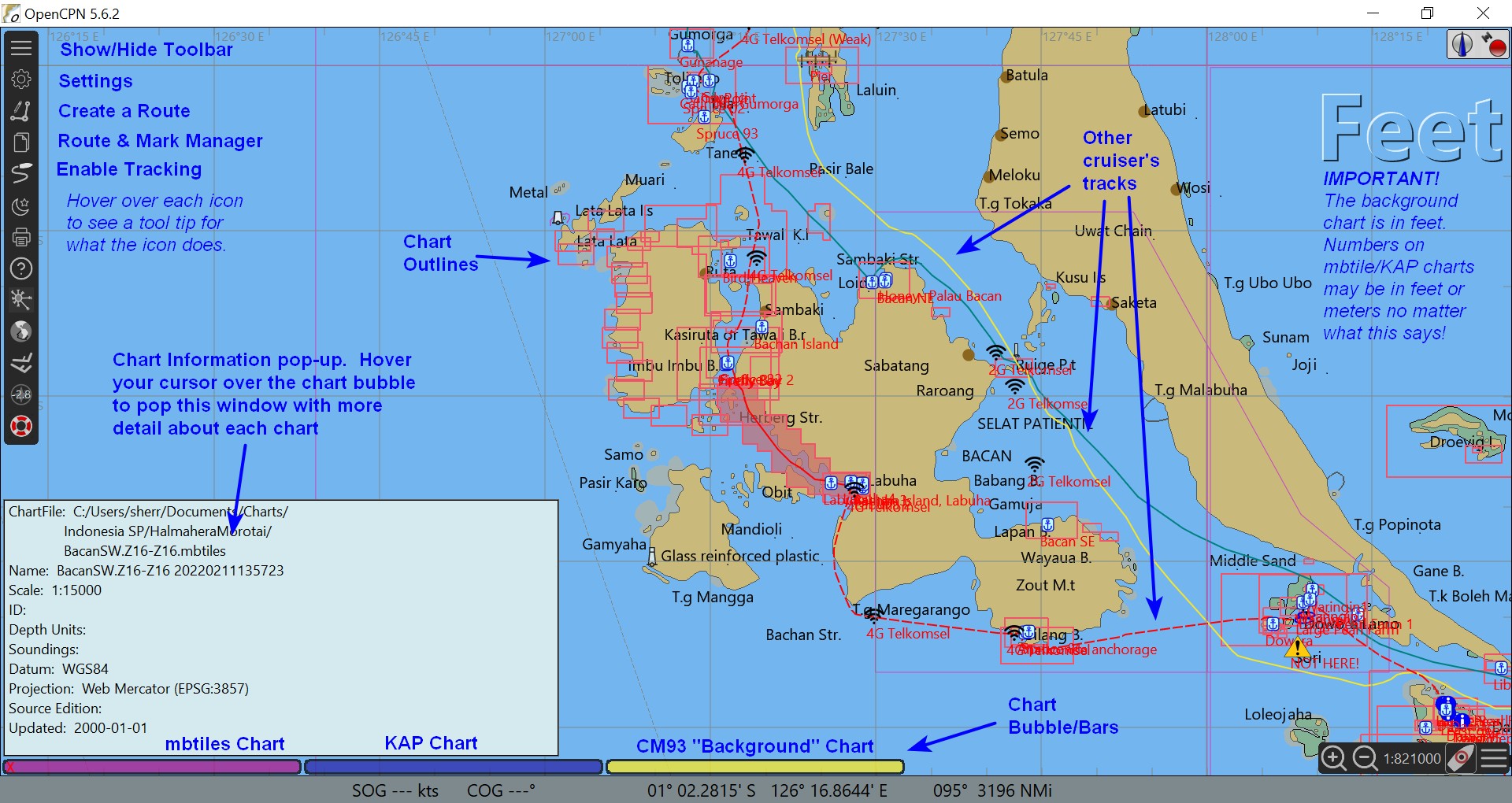
7. Make sure you have "show chart outlines" display option turned on. (shortcut: type "o" on the keyboard toggles show and hide chart outlines). You should then see red chart outlines for the areas of charts you have added.
You should also see Blue, Pink, and Yellow/Brown bubble/bars
at the bottom of the Chart area. These will change as you move the
chart around and zoom in and out. These designate the available charts
8. If you have 'chart quilting' turned on in OpenCPN, Play with the light
blue bars (KAP files) and pink bars (mbtiles) at the bottom of the screen to see which level of chart you can
choose. The left-most buttons on the bottom of the chart table are the
most detailed charts, and the right-most are the least detailed.
To zoom in and out, the easiest way is with the + and - keys on your
keyboard.
Download FREE OpenCPN Open Source Chart Plotter / Navigator
Source for the "Background Chart" (search doc for CM93)
Easy Steps to Make Your Own Satellite Chart
To Use with Maxsea 10.3.2.1 (KAP charts only)
Put the chart folders where ever you want them to be. For example:
C:\Charts\GoogleEarth\Fiji
To load the charts into Maxsea, click File / Open (NOT Open Chart)
Navigate to the folder where the charts are. Click on ANY KAP file (the
individual chart files inside the folder), and click the Open button. Maxsea
will load all the chart files in that folder. For multiple folders (ie Fiji,
Vavau, etc), repeat for each folder.
These charts will now show up in a DIFFERENT window than the C-MAP (CM93)
chart window that you are used to. To switch between windows, click Window
on the main menu, and then either Raster or CM92Ed2.
Note that in Maxsea, these two windows are de-coupled. The routes will
always show up in both windows, but the current view (ie zoomed in or zoomed
out, etc) and the layer files are maintained independently. You can have a
layer turned on for CM93 and not turned on for Raster and vice versa. You
can be really zoomed in in Raster and zoomed out in CM93.
The only way I have found to remove chart loading in Maxsea is to shut down Maxsea, rename the folder to something else (temporarily), and start Maxsea back up. Not finding the folder, it forgets about it permanently.
To use with Maxsea Time Zero
You are completely out of luck! Furuno's Maxsea Time Zero product calls these 'legacy' charts. They would much rather you buy charts from then than get them free off the internet. You cannot use these charts with Maxsea Time Zero. Their help files essentially say, you can keep your legacy version of Maxsea (or other charting program) installed along with Time Zero.
The New Soggy Paws in Raja Ampat June 2016